EM31Mk2
from Geonics
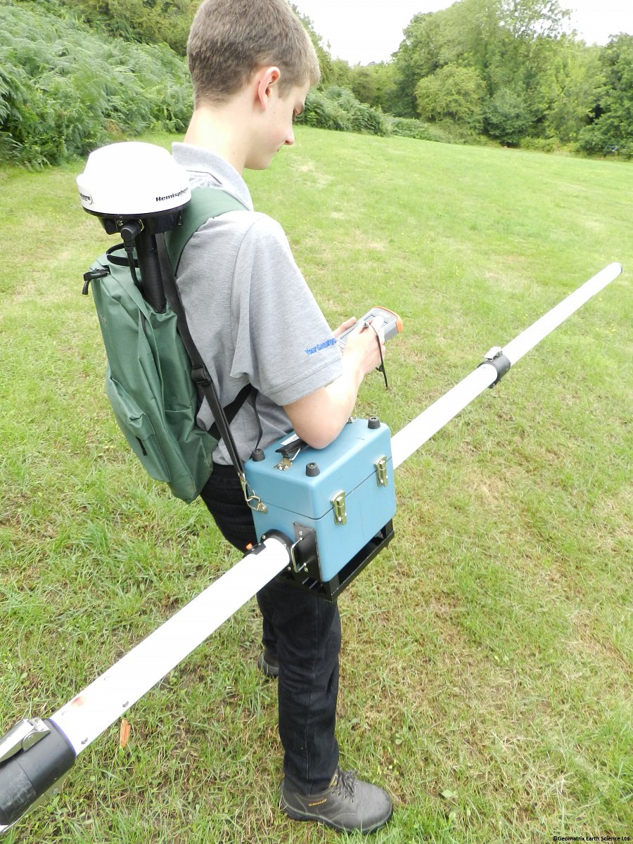
The EM31-MK2 is an updated version of the standard EM31. Ground conductivity and in-phase measurements are read directly from the data logger screen. Data is transferred wirelessly from the instrument to the data logger via Bluetooth communication. The data logger is readily removed from the console for easy data handling or, if preferred hand carried during the survey.
The EM31-MK2 maps geological variations, groundwater contaminants or any subsurface feature associated with changes in the ground conductivity using a patented electromagnetic inductive technique that makes the measurements without electrodes or ground contact. With this inductive method, surveys can be carried out under most geological conditions including those of high surface resistivity such as sand, gravel and asphalt.
The effective depth of exploration is about six meters, making it ideal for many geotechnical and groundwater contaminant surveys. Important advantages of the EM31-MK2 over conventional resistivity methods are the speed with which surveys can be conducted, the precision with which small changes in conductivity can be measured and the continuous readout and data collection while traversing the survey area. The in-phase component is especially useful for detecting shallow ore bodies and buried metal hazardous waste.
For applications where a shallower investigation depth is required Geonics offer the EM31-SH. The EM31-SH is a variant of the EM31MK2 with a shorter 2m coil separation effectively improving lateral resolution and reducing the depth of investigation to 3m.
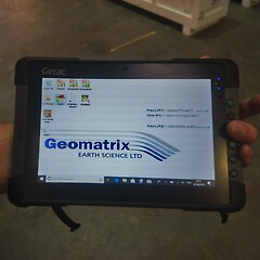
For large area surveying Geomatrix recommends the use of the Messa 2 ultra-rugged Windows 10 tablet running RTMAP 31 data acquisition software from Geomar Software Inc. Geomar produce a whole suite of data acquisition and navigation packages for many instruments which integrate GPS positions to guide the operator in real time, eliminating the need to establish a local grid and will contour and plot data as it is being recorded.
Product Dimensions
| Physical | Dimensions (L x W x H) | Weight |
|---|---|---|
| EM31Mk2 (instrument only) | 400cm x 15cm x 22cm | 12.4kg |
Technical Specifications
| Measured Quantities: | - Apparent conductivity in millisiemens per metre (mS/m) - In-phase ratio of the secondary to primary magnetic field in parts per thousand (ppt) |
|---|---|
| Primary Field Source: | Self-contained dipole transmitter. |
| Sensor: | Self-contained dipole receiver. |
| Intercoil Spacing: | 3.66 metres. |
| Operating Frequency: | 9.8 kHz. |
| Power Supply: | 8 disposable alkaline 'C' cells (approx. 20h continuous). |
| Measuring Ranges: | Conductivity: 10, 100, 1000 mS/m In-phase: +/- 20ppt |
| Measurement Resolution: | +/- 0.1% of full scale. |
| Measurement Accuracy: | +/- 5% at 20 mS/m. |
| Noise Levels: | Conductivity: 0.1 mS/m In-phase: 0.03ppt |
| Data Storage: | 10,000 records (2 components); 16,500 records (1 component) (ext. memory available). |
Shipping
| Contents | Dimensions (L x W x H) | Weight |
|---|---|---|
|
Case1
EM31MK2, data logger and GPS |
145cm x 38cm x 23cm | 28kg |
Data Sheet
- EM31Mk2 Datasheet (PDF)
Literature
- TN-5- Electrical Conductivity of Soils and Rocks (PDF 7MB)
- TN-6- Conductivity at low induction numbers (PDF 4MB)
- Why doesn't geonics limited build a multi frequency EM31 or EM38 (PDF 34KB)
Checklists
- Checklist for Data Storage and Transfer (PDF 249KB)
- Checklist for EM31 or EM38 Operating Procedures (PDF 235KB)
- Checklist for Field Editing (PDF 244KB)
- Checklist for Instrument Storage (PDF 138KB)
- Checklist for Out of Box Equipment Tests (PDF 228KB)
Gallery
FAQ's
The EM31MK2 is not communicating with the Archer2 datalogger via the RS232 cable
Problem:
Com Port conflict
Solution:
Check Com Port for the EM31MK2 has been changed to COM1 under Logger Setup menu and the GPS is not enabled and set to the same port.
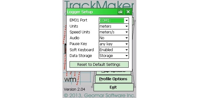
Explanation:
The serial D9 (RS232) connector on the Archer2 is assigned as default to be Com Port 1. Before supplying the EM31MK2 for rental we configure the software so that the EM31MK2 reading are received via Bluetooth and the GPS is connected via the native serial port on the Archer2. If the intention is for the EM31MK2 to be connected connected to the Archer2 native serial port the operator will need to disable the GPS (under the GPS Setup menu) and reassign Com Port 1 to the EM31MK2 (under the Logger Setup menu).
The Archer 2 includes a built in GNSS chip which is assigned to Com Port 2. If the intention is to connect the EM31MK2 to the Archer2 via RS232 then we advise recording the internal GNSS for an accurate time stamp.
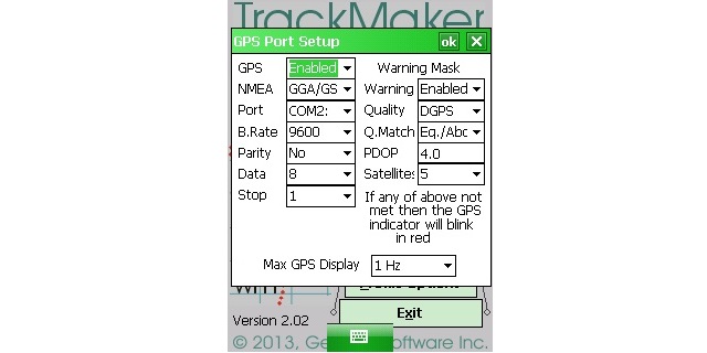
Why does NAV or RTMap31 present ‘Cannot Open EM31MK2 serial Port’?
Problem:
The EM31MK2 has gone though many revisions over the life span of the product. When Geonics moved to using third party data loggers like the Allegro, Archer, Archer2 and now rugged tablets with Windows OS the digital LCD display was removed which indicated if the batteries were completely depleted. The result of this was that it became harder to determine if the batteries were flat, installed incorrectly or if the Bluetooth settings were incorrect. Since 2018 Geonics have been installing LED on the EM31MK2 which indicates if the batteries have sufficient power.
Solution:
If your EM31MK2 is Bluetooth enabled and use one of the data loggers listed above then we suggest keeping it simple can connecting via the EM31MK2 to serial cable first.
Turn the EM31MK2 to Opp and the gain switch to Batt.
Note the Transmitter and Receiver do not need to be connected to run this test.
Navigate to the Nav31 or RTMap31 program on your device and change the EM31 port setting to Com1 under the Logger Setup menu. Make sure the EM31 is enabled. Next navigate to the GPS Setup Menu and disable the GPS for the time being.
Navigate back to the program main menu and click on Logging. If the ‘Cannot Open EM31MK2 serial Port’ message is displayed then remove the battery cradle from the EM31MK2 and check there is no corrosion on the contacts and all contacts are in firm contact with the battery terminals. Also check that none of the batteries are installed the wrong way round. If all appears in good order replace the batteries with a new set.
If the error message is not displayed, check C and I read >4.4V. As long as these values are greater than 4.4V the batter power is sufficient and the issue lies with the Bluetooth com port allocation.
Please refer to our Bluetooth troubleshooting guide under the FAQs for further guidance.