Electrical Resistivity
Marine Resistivity - Syscal Pro Deep Marine
Marine resistivity is a powerful, non-invasive geophysical technique widely employed in geotechnical, geo-environmental, and coastal/marine studies. It is particularly effective for preliminary investigations of coastal or seabed areas that exhibit scientific or engineering interest. Applications include assessing seawater intrusion into coastal groundwater aquifers (notably in karstic environments) and mapping the spatial and temporal distribution of freshwater discharge into marine environments.
Additionally, marine resistivity is utilized to analyze seabed characteristics such as faulting, porosity, heterogeneity, and void ratio, as well as the influence of tidal forces. These factors often serve as pathways for saline intrusion, impacting the coastal ecosystem and subsurface stability.
Key Applications:
- Seawater intrusion detection: Monitoring the ingress of saline water into freshwater aquifers.
- Seabed sediment analysis: Examining void ratios, clay content, and heterogeneity.
- Permafrost melt studies: Assessing instability in polar seabed regions caused by freshwater seepage.
- Fault and fracture mapping: Identifying fractured bedrock or sediments prone to collapse or instability.
Coastal surveys often rely on schematic geotechnical models derived from borehole records and numerical modeling. However, resistivity imaging using 2D inversion models provides more accurate and actionable insights, enabling users to identify and mitigate risks. These include areas of highly fractured sedimentary bedrock, saturated marine clays (noted for their high plasticity, moisture, and salt content), and zones affected by permafrost melt.
Syscal Pro Deep Marine System Deployment: The Syscal Pro Deep Marine system is adaptable for both floating and submerged array configurations:
1 - Floating Array: Ideal for imaging both seabed resistivities and variations in water column resistivity and salinity.
- Configuration: 13 graphite electrodes (11 potential electrodes and 2 current electrodes) spaced 5 meters apart.
- Typical Use: Saltwater environments with water depths between 1 and 4 meters.
- Operation: Towed behind a boat moving at 3-4 km/h. 2 - Submerged Array:
- Suitable for environments requiring higher resolution seabed imaging.
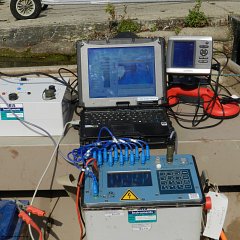
To ensure reliable measurements in saltwater environments, the system utilizes a reciprocal Wenner array and employs a high-current output to overcome the conductivity challenges posed by seawater (Fig. 1).
This robust marine resistivity system offers advanced capabilities for researchers and engineers working in coastal and marine environments, delivering actionable insights critical for environmental management and infrastructure planning.

The deep-water towing method, (figure 2) as described, involves deploying a 10-channel 13-graphite electrode array with 11 potential electrodes and two current electrodes, positioned 4 meters above the seabed. The deployment is facilitated by a 25-meter deck lead and floats, with the electrodes separated by more than 70 meters of rope. This setup allows for more effective imaging of the seabed by minimizing the influence of the water column, which often interferes with depth penetration in marine geophysical surveys. By positioning the electrodes at a significant depth, this method enhances the quality and accuracy of subsurface imaging, providing clearer insights into the seabed conditions.

When working in freshwater environments such as rivers, estuaries, and reservoirs, it is recommended to use the Syscal Pro system rather than a deep marine system. The Syscal Pro is designed for land-based and shallow water applications, making it more suitable for freshwater environments where the depth and water conductivity differ significantly from deep marine settings.