Geode EM3D
from Geometrics
Modern exploration for minerals, shallow oil and gas, and groundwater requires more high-quality data acquired and processed faster and at a lower cost than traditional EM techniques. Now you can do distributed EM surveys with confidence.The multi-channel Geode EM3D allows simultaneous soundings at up to 160 locations, greatly improving field efficiency. Based on our tried-and-true Geode seismic technology, the Geode EM3D truly revolutionises AMT data acquisition.
The system passively measured natural field signals within the Audio bandwidth and induced signals from transmitters, or a combination of both (HSAMT).The defining characteristic of a distributed, networked system is that it is flexible in size. There can be numerous network nodes, each making its own measurements and sending the results back to a central controller computer. The definition of a network node in the Geode EM3D is a single receiver box with up to six channels. Every node communicates to the other nodes and the Master Node by way of a hardwired Ethernet cable. A single node can be configured to have up to three magnetic coils or up to six electric field dipoles. The Geode EM 3D is scalable from 6 to 240 channels, so the system can grow with your business.

Features
- Hybrid-source vertical induction loop transmitter with frequency range 1 kHz to 16 kHz.
- Rapid contact resistance measurements for all E-field channels provided from the controller-data logger computer.
- Rapid DC and AC noise levels for all E-field and H-field channels.
- Flexible set-up, each node can be configured with either six E fields, or four E fields and two H fields.
- Frequency domain cross power stacking. Stacking for longer ensures that the enough natural events occur across the full bandwidth resulting in improved modal coherency.
- 0.1-20kHz sampling, leading to 15-1000m depth of exploration.
- Local referencing with 2 or more GeodeEM3D reduces electrical and internal noise. Both stations must have E & H fields.
- Real-time data processing during acquisition to display impedance curves, phase curves, Bostick transform soundings, and other MT-AMT parameters. The Geode EM3D software gives the operator immediate feedback on the quality of the data and view of all processed data in the field.
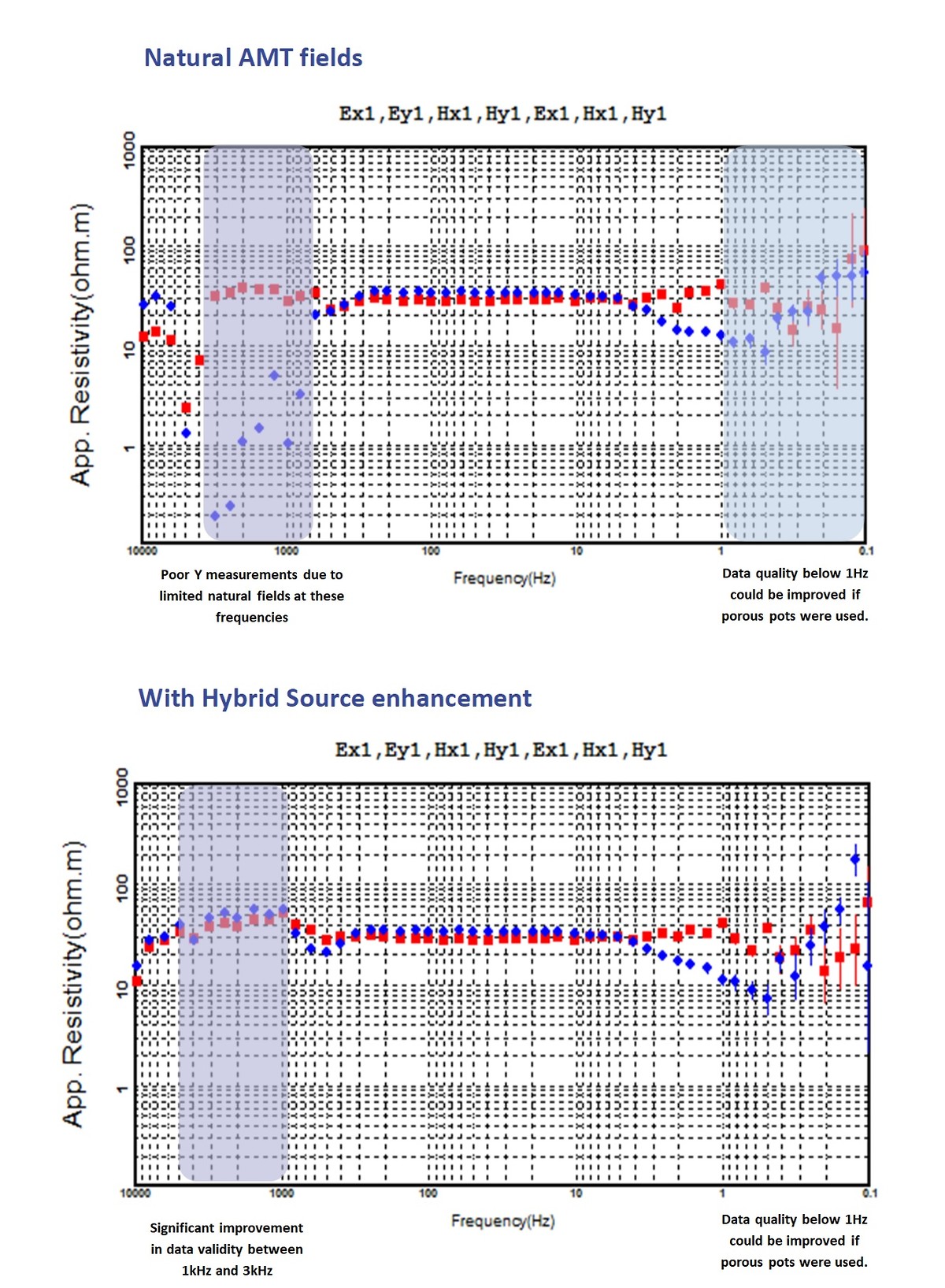
There is a band of frequency between about 1kHz and 4kHz that are traditionally weak in MT signals. This is known as the natural-field dead zone. the atmosphere isn’t an efficient wave guide within this frequency bandwidth and the fields radiate out into space. The HSAMT portable transmitter is unique to the Geode EM3D and used to enhance the signals in the AMT dead-zone and improve shallow resolution by propagating fields above 4kHz which do not occur naturally. No modification is required to the receiver array as these supplementary signals look to the receiver like natural field signals.
Product Dimensions
| Physical | Dimensions (L x W x H) | Weight |
|---|---|---|
| Geode EM3D (instrument only) | 24cm x 16cm x 19cm | 5.2kg geode em3d only |
Technical Specifications
| Frequency Range: | 0.1 Hz to 20 kHz |
|---|---|
| Electric Sensors: | stainless Steel Stakes for up to 1.5km depth of exploration. Porous Pots non-polarising required for exploration deeper than 1.5km |
| Magnetic Sensors: | Model G20K (0.1 Hz to 20 kHz) magnetic field sensor with 20 meter cables |
| Sample Interval: | Automatic or manually selected |
| Maximum Record length: | 64 K samples |
| A/D Conversion: | 24 bits |
| Dynamic Range: | 144 dB (system), 110 dB (instantaneous, measured) at 2 ms, 24 dB |
| Noise floor: | 10 nV/ HZrms @ 24 dB |
| Storage Memory: | PC system dependent |
| Gain Settings: | 24 dB, 12 dB, 0 dB, -12 dB |
| Maximum Distance from receiver: | 250 m between receivers,100 m first receiver to PC. |
| Analogue Receiver Input Impedance: | > 2.0 MOhm (W/Analog Front end) |
| Power source and consumption: | Geode EM3D Receiver 12V external battery, 9 Watts for 6 channels. |
| Operating Temperature: | 20°C to +70°C |
| Maximum signal input voltage: | +/- 12 V peak, +/- 9 V peak before distortion increase |
| Clock Accuracy: | 0.4 ppm over temp range, +/- 2ppm/year without factory calibration. |
| Phase Matching: | 1 degree <1 kHz, 3 degrees< 10 kHz |
| Amplitude-Phase Channel Matching: | 1% |
| Amplitude Accuracy: | 1% |
| Maximum Channels: | 240 channels |
| Communication Protocol: | 10 Mbit Ethernet |
| GPS Synchronization: | Synchronized transmitter to acquisition stations |
| In-field QC: | Time series, apparent resistivity and phase versus frequency sounding curves with standard deviation or error bar, component operation check, automated contact resistance measurement |
Shipping
| Contents | Dimensions (L x W x H) | Weight |
|---|---|---|
|
Case 1
Geode EM3D, cables and electrodes |
60cm x 50cm x 50cm | 30kg |
|
Case 2
Magnetic sensors |
150cm x 40cm x 15cm | 25kg |
|
Case 3
Hybrid Transmitter antenna |
150cm x 30cm x 25cm | 10kg |
|
Case 4
Hybrid Transmitter controller, cables and remote |
60cm x 50cm x 50cm | 25kg |
Shipping Notes:
Basic single node system with transmitter.
Data Sheet
- Geode EM3D Datasheet (PDF)