Vehicle Raptor
from ImpulseRadar
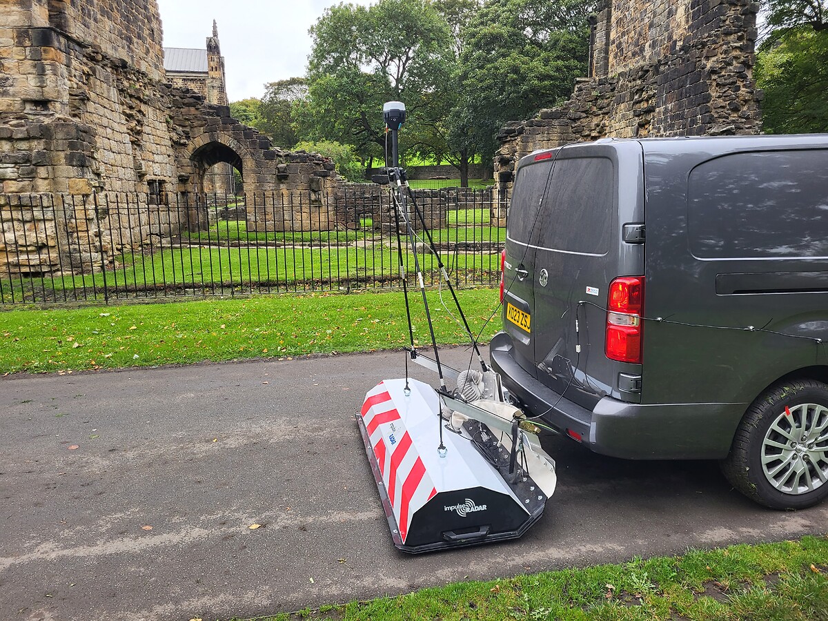
The raptor series are a set of High speed GPR systems which use real time sampling (RTS) technology to obtain accurate and fast results in a variety of applications. The Vehicle carrier option (Fig.1) allows the operator to choose between a 18 channel arrangement for the 450MHz antenna up to an 28 channel array for the 800MHz antenna. The robust design of the raptor vehicle array, allows the user to fix the carrier to survey vehicles with ease, allowing fast data collection in regulated traffic flows. Once the survey is finished the carrier can be easily stored in the back of your vehicle and transported for use on a number of project sites.

In terms of the data collection, the data acquired over each survey line can be combined with an RTK GPS system with a GGA NEMA string output, improving the accuracy (the internal GPS is used to time stamp the data 1pps rate), the data can be gathered over a single swath over one pass enabling efficient data collection. If there are zones/ survey areas with limited coverage such as beneath bridges, close to overhanging trees etc. there is an option to connect a total station instead of the external GPS to avoid missing positional data.
The Raptor communicates with a windows tablet over ethernet connection via an IP address, the data cable provided is long enough so that the operator can sit in the passenger’s seat of the vehicle to view the data. An odometer c/w cable can fix onto the hub cap of the vehicle wheel to accurately measure the distance travelled.
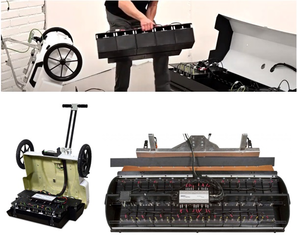
Using the same technology as the cart system the antennas are interchangeable (Fig. 2), and the inner set of antennas (8ch (450Mhz antenna) or 12ch (800MHz antenna)) can be used in the cart set up or the Vehicle mount depending on the users requirements.
For the lower frequency 450MHz antenna will allow the user to image till 5m depth, example applications would be archaeological, civil structure utility and railway mapping. A more detailed scan of the upper surface of ground can be obtained with the 800MHZ antenna reaching maximum 2m depth (UK) this antenna is typically used to image roadbed layers and concrete scanning.
The data acquired using the Talon II acquisition software can be stored on your windows tablet and transferred using a standard USB device. The output files are in .Irp format with the separate files including .gps, .time. The user can use any compatible software, however the Condor software has been specifically designed to handle this 3D data and interpolate the X,Y,Z data and any features in osprey view. After interpreting the data, this can easily be exported to a CAD readable format.
Features
- Fast data collection at 130km/hr, 5cm point interval
- High Dynamic range and deep penetration
- Small Point interval and rapid data collection regardless of the number of channels
- Low Weight
- Flexible, modular and plug and play configuration of antennas, no control unit
Product Dimensions
| Physical | Dimensions (L x W x H) | Weight |
|---|---|---|
| Vehicle Raptor (instrument only) | 1900 x 800 x 600 | 87 kg (450mhz) or 77 kg (800mhz) |
Technical Specifications
| Antenna Center Frequency: | 450MHz or 800MHz |
|---|---|
| Antenna Footprint: | 165 x 230 mm or 110 x 150 mm |
| Antenna Weight: | 1.86 kg or 0.95 kg |
| Antenna Polarization for both antennas: | VV or HH |
| N.o Antennas: | 18 or 28 |
| Scan Width: | 1400 mm |
| Vehicle system weight and dimensions: | 87 kg; 1900 x 800 x 600 mm or 77kg; 1900 x 800 x 600 mm |
| Power Consumption: | 108 W or 168 W |
| Maximum System Configuration: | 30 Channels |
| Environmental Rating: | IP 65 |
Shipping
| Contents | Dimensions (L x W x H) | Weight |
|---|---|---|
| Vehicle Raptor (450 MHz) | 1900 mm x 920 mm x 720 mm | 130 kg |
| Vehicle Raptor (800 MHz) | 1900 mm x 920 mm x 720 mm | 150 kg |
Data Sheet
- Vehicle Raptor Datasheet (PDF)