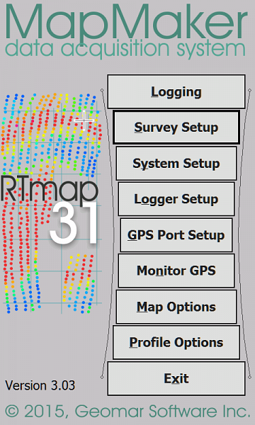
RTMap31
from Geomar
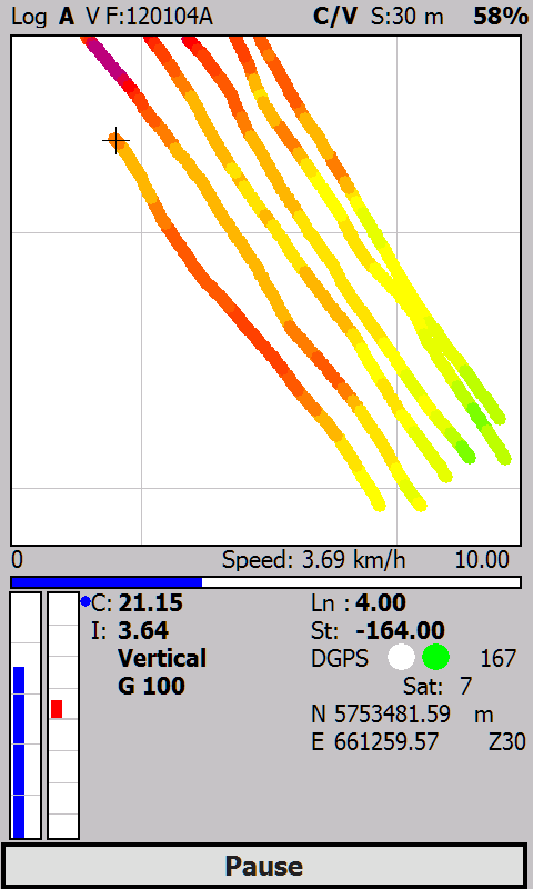
The RTmap31 system will provide unmatched real time QA/QC and speed in the field. Viewing the displayed spatial image will allow the user to adjust the survey speed according to where anomalies are seen. The RTmap31 will allow you to perform surveys faster by covering sites with uniformly spaced lines while avoiding skipping areas, and preventing the potential unnecessary overlap of survey lines. And with above features also comes the simultaneous full control of the EM31 output, data quality, EM31 settings, as well as GPS receiver parameters and GPS warning mask.
RTMap will apply a colour scale to the conductivity or in-phase measurements in real time, so the operator can identify data trends and if necessary fill in line to better delineate anomalous regions.
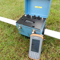
GPS positions and EM31MK2 measurements are captured from their respective Comm Ports and time stamped by the software before being recorded. If the EM31MK2 and GPS system are Bluetooth enabled then the recording package can be completely wireless.
Files can be reviewed or loaded to new projects in order to resurvey an area for monitoring purposes, or to fill-in areas of spars data coverage. In addition way points and markers can be uploaded to the display to aid operator orientation.
The RTmap31 program works with virtually any GPS receiver by supporting NMEA messages: GGA, POS, GLL, LLQ, LLK, GGK, and selected Robotics Total Stations, and collects EM31 and GPS data into one file simultaneously, while providing a graphical view of amplitude (pseudo-grid) in real time.
RTMap31 consists of two programs: RTMap31wm is a Windows Embedded data acquisition software package which will run on most rugged handheld data loggers, our preference is the Archer2 by Juniper Systems. An accompanying post processing software packaged is supplied which converts the binary record files to a XYZ format (includes Surfer and Geosoft formats).
Features:
- Field QC parameters (Real Time contouring, Quality Indicator, number of Satellites and PDOP)
- Option to act as a stand-alone GPS logger (includes fast auto mode as well as more precise positions averaging), which allows data to be collected in GXY file format.
- Apply GPS antenna offset
- Convert RTMap31 files to Geonics DAT31 format.
- Retrieve and position field comments.
- Apply System Time Constant delay (lag)
Technical Specifications
| Operating Software: | RTMap31wm- Windows Embedded RTMap31 - Windows XP-10. |
|---|---|
| Sample Rate: | EM31MK2 -10Hz GPS -2Hz. |
| Survey modes: | Timed or Manual trigger. |
| NMEA messages: | GGA, GGA/GSA, GLL, POS, LLQ, LLK, GGK, and stream of Leica and Trimble Robotics Total Stations |
| GPS Transformations: | Geodetic coordinates (Latitude/Longitude in degrees) or UTM coordinates (meters, feet or US Survey Feet, WGS1984 datum) |
Data Sheet
- RTMap31 Datasheet (PDF)