Geomatrix Earth Science Ltd have been appointed the UK sales agent for Oceanic Imaging Consultants Inc. To mark this news we are offering a special show discount on all OIC software.
SAMM is a Stand Alone Mosaicking Module designed to run alongside existing manufacturers data acquisition programs to enhance survey capability by proving real-time mosaicking, georeferenced charts, satellite imagery overlays and geo-coded observation classification.
SAMM with Forward looking sonar
CleanSweep provides a powerful processing platform for hydrographic survey data management, processing and analysis. Multibeam, Side Scan, Forward Look and Interferometric datasets can all be processing in one work space.
GeoDAS is a comprehensive data acquisition package for conducting hydrographic surveys. Capable of interfacing with market leading hydrographic equipment GeoDAS offers a wide variety of real-time correction tools and cartographic functions.
Geometrics release a new Seismograph - the ATOM
18 December 2017
The ATOM introduces a new style of seismograph to the Geometrics Inc range. As a stand-a-lone seismograph each Acquisition Unit (AU) is a complete recording system providing total flexibility over the number of data acquisition channels.
Containing an internal battery, high accuracy GPS clock and 4 GB memory the ATOM can be deployed for up to 70 hours of continual data acquisition before recharge. For longer monitoring projects the addition of a small 5V solar panel permits data acquisition to be extended to up to 23 days with the 4GB standard internal memory; or 186 days with the optional 32GB extended memory.
No compromises have been made in terms of the performance of the system; offering up to 0.25ms sample rate the bandwidth of the system is 1.5kHz to 1650kHz with 128dB 24bit dynamic range.
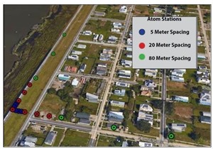
L-shaped array with non-uniform spacing in the Lower 9th Ward, New Orleans, using the ATOM Passive Wave Wireless Seismic system
Operating the instrument couldn’t be easier. Users turn the boxes on by shaking them. The box will automatically begin recording as soon as it achieves GPS lock. LEDs inform the operator of the battery status, network state, GPS time lock and geophone connection. Data is retrievable via WiFi and a laptop.
When combined with the semi-automatous SeisImager Passive Wave processing software the system is ideally suited for obtaining shear wave velocity measurements to depth up to 1km.
Compatible with any standard geophone the ATOM offers flexibility where many other similar systems don’t. A version of the ATOM with 3 measurement channels will soon hit the market; changing the face of how shallow 3 component data acquisition for geological engineering is conducted.
For further information about the ATOM seismograph please feel free to contact us through our enquiry form. Alternatively sign-up to our newsletter and we will keep you informed about all the latest instrument developments.
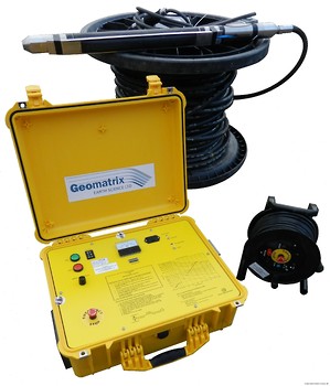
ATOM Seismographs with 2Hz geophones.
New IPG800 Downhole S-Wave source added to the rental pool
7 November 2017
Geomatrix have added a IPG800 downhole seismic source to the rental pool to support customers undertaking shallow cross hole seismic investigations. The IGP800 is a lightweight portable downhole source designed to operate the BIS-SH at up to depths of 60m. The BIS-SH is a horizontal source for S-wave generation, and also provides good P-wave generation. The addtion of the IPG800 allows supports our existing IPG5000 with 100m P-wave (sparker) and S-wave sources.
Capable of being powered from a 24V DC supply the IPG800 is easy to use and more portable than other borehole S-wave sources.
The FINDIT project picks up ‘Best Collaborative Work’ at the street Works UK Awards 2017.
20 October 2017
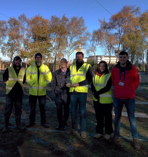
The team at the newly constructed BT test site.
The FINDIT project looks towards developing new geophysical methods which can be used to guide the maintenance and development workflows of subsurface infrastructure.
The project combines the expertise from the University Birmingham, RSK, Geomatrix Earth Science and BT to identify methods for measuring common problems with underground asset; these include blockages, congestion and damage.
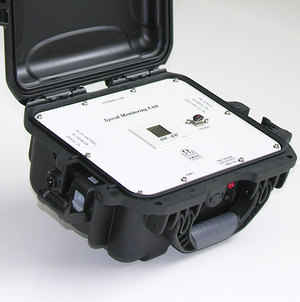
Syscal Monitoring Unit (SMU)
1 May 2017
The Syscal monitoring Unit is an automated system designed to allow the operator to remotely manage the recharging of the Syscal Pro transmitter and receiver batteries during a monitoring survey.
The SMU connects the Rx and Tx batteries to an alternative source of power (solar panel, wind turbine, isolated charger, ethanol fuel cell) when the Syscal is not acquiring. During the acquisition, the external power supply is remotley disconnected from the Tx and Rx batteries to avoid any leak of current that would perturbate the measurements.
For further information click on the adjacent image.