Our CG6 Micro Gravity meters were able to capture the event that shook the local area around 9:45am this morning. Depicted as a sharp peak within our drift profiles the recorded high was around 5164mgal, a 9.5 mGal difference from the normal 5154.5 mGal average.
Fig.1. G9 Drift data showing the time of the earthquake
Fig.2. G10 Drift data showing the time of the earthquake
COVID-19 Update - Rental and Repair Services Remain Open
25 March 2020
In line with government guidance we continue to support customers by supplying geophysical equipment rental & repair services.
The courier services we use are operating within normal capacity.
We are open for business with essential staff only and can ship and receive equipment within our normal capacity. We will facilitate collections and accept hand deliveries, but social distancing measures will be adhered to.
Engineers are available for technical support calls and sales staff are all working from home with full access to our systems.
In addition to the measures we implemented last week, we have also introduced the following;
(Implemented as of the 24th of March)
We are asking customers to unload their vehicles and leave the equipment on the threshold of the loading bay and stand back to allow Geomatrix staff to handle the equipment.
We will wipe down all transit cases/Instrument handles & caches with alcohol wipes before it is permitted to enter the premises
All instrumentation will be handled with gloves
We are taking precautions to reduce the risk of virus transfer from instrument keypads and screens
We have sufficient equipment within the rental pool to accommodate these additional measures without causing a delay to our services.
If you have any questions, please get in touch by calling the office on +44 (0)1525 383438 or email us at sales@geomatrix.co.uk
COVID-19 Update - We're Still Open For Business
18 March 2020
We’re taking precautions, and we are still open for business
We’re confident that our processes mean rentals of equipment which we own will always go out on time, and that sales of equipment from third party suppliers or principals are being monitored and managed.
What are we doing to ensure we can continue to deliver a normal service?
We will continue to operate as normal and follow Public Health England (PHE) & Government’s advice on a day-by-day basis.
We have remote access to our customer order information so we can fully support our clients as normal from any location.
We are currently receiving a normal service from our couriers and we are monitoring their operational capacity as events develop.
We will continue to monitor the situation and update you if anything changes via email and our website.
If you have any questions, please get in touch by calling the office on +44 (0)1525 383438 or email us at sales@geomatrix.co.uk
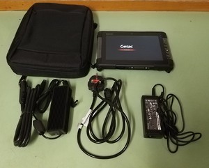
New: Getac Tablet Data Loggers!
5 August 2019
From today we are upgrading our old Allegro and Archer data loggers to the new Getac tablets. All six tablets support windows 10, come equipped with a battery charger, backup USB and are fully installed with RTmap (31,61MK2 and 38MK2) and RTM(31,61 and 38) acquisition/processing packages. These will help improve the way data is collected in the field, allowing for more rapid, high quality and reliable data acquisition.
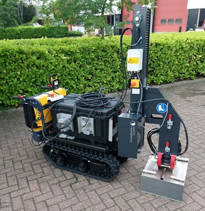
Geomatrix add a Lightning Seismic vibrator system to the rental pool.
24 July 2019
The Lightning Seismic Vibrator source has been developed or near surface ground engineering and exploration. Able to generate either compression or shear waves at forces exceeding 1000N this portable source is ideal for shallow seismic reflection or complimenting passive seismic records.
The electric tracked vehicle supplied with the Lightning rental system can be loaded into the back of a high top van fully assembled for easy fast transport and deployment. With sufficient battery power for one and half days of field operation the tracked electric vehicle can cope with inclines of up to 15º and access areas which are restricted to vehicles.